22.12.22
Editorial Note
In 2012, the Israeli Council for Higher Education almost closed down the Department of Politics and Government at Ben Gurion University because of its activist nature. The Evaluation Committee of the Council found that instead of offering a core curriculum, the courses were essentially an extension of the political agenda of many of the faculty. The Department promised to change its curriculum, but the strong pollical orientation has persisted. Dr. Hagit Keysar, currently a postdoc at the Minerva Center for Human Rights at Tel Aviv University, who completed her doctorate in the Department in 2017, is a case in point.
Keysar was inspired in 2011 by the Public Laboratory for Open Technology and Science (Public Lab), an activist group in the United States formed to document the British Petroleum spill in the Gulf of Mexico. She joined them and met Jeffrey Warren, one of the co-founders of the Public Lab, during her research for her MA degree, “Do-It-Yourself Aerial Photography in Jerusalem.” Warren was invited to give a series of workshops for the Mamuta Art and Media Center where she studied. One workshop they organized with Palestinian residents of East Jerusalem in the neighborhood of Silwan who expressed interest in creating their own high-resolution aerial photographs to visualize the intricate details of “spatial and political violence” experienced on a daily basis. “For the people we worked with in Silwan, DIY aerial photography was seen as a tactic that had the potential to disrupt the mechanisms of surveillance and visual control that order and organize the visibility and publicity of the conflict in Palestinian Jerusalem,” she wrote.
According to her Ph.D. thesis, “Prototyping the civic view from above” is both a “critique and a creative practice that examines political questions relating to DIY aerial photography by conducting critical analysis and ethnographic research. The present research aims to critically examine these circular relations between tools, issues, and communities; to experiment with these practices and analyze them in a setting of urban-political conflict. The possibility for a civic view from above is considered here within its historical and theoretical contexts; it is examined in relation to existing strata of civic views from above, which are inseparable from the history of military aerial visualization and power.” She wrote. The main purpose of her research is to “experiment with and analyze how DIY aerial photography, as part of a broader set of practices termed by Public Lab as ‘civic science,’ functions in the context of urban and ethno-political conflict in Israel/Palestine.”
She explains that “Public Lab’s idea of civic science establishes connections between public participation in science and the production of knowledge commons by opening the material, social, and literary processes and tools for creating scientific knowledge.”
Keysar further explains that her research follows the parameters of “engaged ethnography,” which essentially means that the research-activists create a certain reality that fits their political goals. In her words, “this work demonstrates various forms of involvement within political and activist arenas that need to be critically addressed.” Adding further, “it demonstrates the production of spaces of collaboration within changing contexts of scientific and political activism.” Consequentially, “activism, as these cases demonstrate, is oriented toward the creation of critical alternatives.” In plain English, the “space” which they produce can be used to bash Israel.
Keysar, a loyal follower of the neo-Marxist, critical paradigm, expands her dissertation to include an attack on “the neoliberal logic, in which ideas and practices of free market and an open and competitive environment are seen as stimulating innovation and economic growth and therefore pushes toward minimizing state intervention and regulation.” This should come as no surprise. While the activist scholars have been normally preoccupied with critiquing Israel for its treatment of the Palestinians, they have a long history of protesting the neoliberal economy, which helped Israel to become a “thriving First-World Economy in a Third World Sea.“
Keysar recently talked at Leiden University in the Netherlands on “Spatial Testimonies, Spatial Photography: Aerial imagery and photogrammetry in spaces of conflict and colonization.”
Unlike many of her peers, Keysar freely admits that she is an academic activist, which she discusses in her dissertation. More than a decade after the Council of Higher Education tried to impose a reform, the Department of Politics and Government is still graduating activists. The Council needs to revisit the issue.
References
Talk by Ariel Caine & Hagit Keysar: Spatial Testimonies, Spatial Photography: Aerial imagery and photogrammetry in spaces of conflict and colonisation | 20 October 2022 | 17:30- 19:30 | Leiden [Register to join]
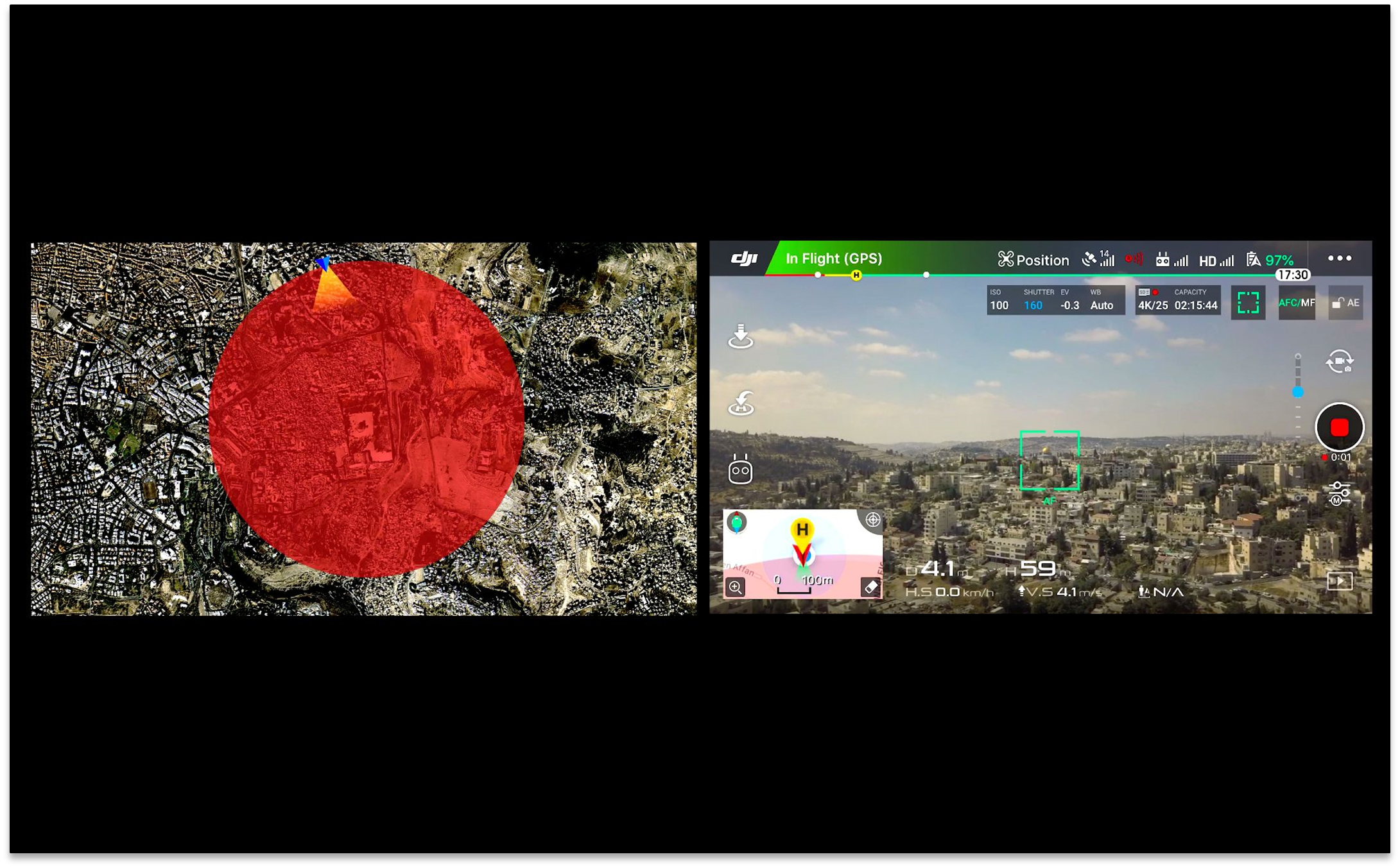
Jerusalem is a city famous for its walls. The walls of the old city, the infamous separation wall. Yet less known is an invisible wall that encapsulates the old city and its surroundings. Centred on the Haram al-Sharif and spanning approximately 3km in diameter. This is what is known as a “Geofence”, a cylindrical digital barrier extending from the ground and up into the skies, set to prevent drone flights into or take-offs within the area. The volume of this technologically restricted zone follows the geographic coordinates of an already present regulatory No-Fly Zone (NFZ), enforced by the Israeli security apparatus for more than two decades.
In the eyes of the Israeli state, the corporate geofence is a sort of panacea. It attempts to give a definitive, albeit partial, solution to the question of sovereignty in this territory. Its technical invisibility and ‘remote neutrality’, allows it to sink below consciousness. However, as a navigational technology it has real-world effects. It reconstructs space in a machine-readable format. Territory altered by machines for machines. Terra ex machina.
In this talk we look into the volatile space of Jerusalem through the prism of the geofence. To begin with, we investigate this new invisible technology of aerial and terrestrial control and continue by contrasting it with tactical forms of resistance, balloon/kite photography, that subvert its technological, epistemological, and ontological standing.
How can we make visible an invisible barrier and its effects? How can we materialise and conceptualise this NFZ and its connected infrustructures?
Biography
Ariel Caine is a Jerusalem-born artist and researcher. His practice centres on the intersection of spatial (three-dimensional) photography, modelling and survey technologies, and their operation within the production of cultural memories and national narratives. Ariel is currently a Postdoctoral fellow at the ICI Berlin, undertaking his project “Architectures of the Sensed: Models as Augmented Sites for Resistance”. He received his PhD from the Centre for Research Architecture, Goldsmiths University of London where from 2016–21 he was a project coordinator and researcher at the Forensic Architecture Agency. In 2021–22 he received a postdoctoral research grant from Gerda Henkel Stiftung as part of the speculative cameras and post-visual security projects at Tampere University (Finland).
Hagit Keysar is a researcher and activist, working and teaching in the fields of science and technology studies, critical data studies and digital urbanism. Her research and creative work concern the politics of data and digitization and the political potentials of community-driven science and technology for articulating rights in situations of conflict and colonisation. She has recently been a research fellow at the Weizenbaum institute for the Internet society, Berlin (2019), a postdoc fellow of the Minerva Stiftung (2019-2021) in Berlin’s Natural History Museum and she is currently a postdoc at the Minerva center for Human Rights at the Tel Aviv University.
When and Where
20 October 2022, from 17:30 to 19:30
LIPSIUS building | Room 003
Cleveringaplaats 1, 2311 BD Leiden
=================================================================
===========================================
https://www.zochrot.org/welcome/search/en?keyword=hagit+keysar
Hagit Keysar in Zochrot
- Ground Truth: Records of Displacement, Return and Environmental Destruction in the Negev/Naqeb
- Here in no-here: Open houses, Exhibitions and Tours
- Qatamon: Annotated Map
- Here in the No-Here
- Ground Truth: Testimonies of Destruction and Return
- Ground Truth: Testimonies of Destruction and Return in the Naqab
- Ground Truth: Records of Displacement, Return and Environmental Destruction in the Negev/Naqab Displacement, Return and Environmental Destruction in the Negev/Naqeb
- Here in no-here: Open houses, Exhibitions and Tours
- Here in the No-Here – Permanent Exhibition in Zochrot’s Gallery Space
- Ground Truth: Testimonies of Destruction and Return | Forensic Architecture (Goldsmith University, London) & Al-Araqib
- Workshop and Seminar: “Operative Models” in the frame of the exhibition “Ground Truth”
- אמת קרקעית: עדויות של נישול, שיבה והרס סביבתי בנגב/אלנַקַבּ
- כאן בַּלּׂא-כאן: בתים פתוחים, תערוכות וסיורים
- קטמון: מפה מוּערת
- ״כאן בַּלֹּא-כָּאן״: תערוכת קבע בחלל התצוגה של זוכרות
- אמת קרקעית: עדויות של הרס ושיבה באל-עראקיב
- אמת קרקעית: עדויות של נישול, שיבה והרס סביבתי בנגב/אל-נַקַבּ
- כאן בַּלּׂא-כָּאן: בתים פתוחים, תערוכות וסיורים
- תערוכת קבע ״כאן בַּלֹּא-כָּאן״ בחלל התצוגה של זוכרות
- תערוכה חדשה: אמת קרקעית: עדויות של הרס ושיבה / Forensic Architectue
- סדנא מעשית וסמינר ״מודלים אופרטיביים״ | במסגרת התערוכה ״אמת קרקעית: עדויות של הרס ושיבה באל-עראקיב״
=============================
חגית קיסר / Keysar Hagit מבט העל האזרחי: צילום אוויר עצמאי בישראל- פלסטין, Prototyping the Civic View from Above: Do-It-Yourself Aerial Photography in Israel- Palestine, בהנחיית: פרופ’ חיים יעקובי, ד”ר מיכל גבעוני, פרופ’ מרדכי חקלאי London University College
https://cargocollective.com/hagitkeysar/hagit-keysar
The Civic View From Above hagit keysar
My research and experiments with DIY aerial photography in Palestine-Israel focuses on civic science in spaces of civic inequality mostly in East/West Jerusalem. It shifts away from the focus on environmental issues; though the environment is always there within a range of systemic rights abuse, from discriminatory urban planning, through land expropriation to forced displacement. I work with communities, NGO’s and local institutions entangled in urgent issues who find it relevant and inspiring to create their own, high quality, local scale aerial photography. Some of the collaborations presented here are activist projects oriented towards a particular issue, workshop or event such as the cases of Beit Safafa and Silwan. Other projects present long term collaborative work which is made possible through ongoing collaborations with affected communities, funded through partnerships with NGO’s and academic programs such as the work we do in west Jerusalem with the civic architecture unit in Bezalel, and the work in the Negev (south of Israel) with Zochrot and Forensic Architecture, and the research collaboration with Dorit Naaman in Qatamon. These collaborations always start with a spark in the eye, a shared imagination, rather than an organized idea on what DIY aerial photography is good for. As an activist and a researcher that work within a space of civil inequality and entangled in it as a privileged citizen, this shared imagination is invaluable. It creates a certain common ground for building up a collaboration that is not entrapped and defined by unequal power relations but on outdoor, hands on and even fun activity and shared concerns between researchers, activists and communities. This is not to say that unequal power relations become a solved problem, this is far from being a reality. But it does mean that we can start imagine new kinds of collective and public actions through technological engagement. The projects presented here are initial threads of thoughts and actions for investigating these ideas.
https://klymtisrael.wixsite.com/riskevent/about
How can you map what cannot be seen on a map and is in constant change and movement? This lecture presents a strand from doctoral research dealing with open source participatory mapping practices and do-it-yourself methods, through a focus on the independent creation of aerial photographs by residents of Jerusalem as a case study for the political and spatial consequences of this type of civic-technological action in a conflicted urban space. Practices for creating aerial photographs independently using accessible and simple tools have been developed during the last four years dealing with The Public Lab by an expanding group of activists, technologists and scientists called in the development of citizen science practices with the aim of expanding the possibilities of research and action around issues of health and environmental justice in local contexts. This study seeks to expand the theory and practice of citizen science focused on challenging and reshaping the concepts and practices of science, to examine the ways in which open technology, do-it-yourself tools and citizen science practices open up the possibility of re-examining the formation of public action and political space. The question and the problem is, how to insert the obvious fact of movement, change, uncertainty and conflict into the map, when we understand that in geography everything is in motion. 1 In the mapping I will present here, which was made jointly by residents, activists and professionals, the map makes it possible to represent, give validity and visibility to burning and worrisome local and planning issues. The mapping process becomes a space of engagement and meeting, where points of contact are created between local issues, residents, professionals and technological activities. Through a phenomenological examination of the mapping process, which is a sort of theoretical and practical laboratory, I will present two test cases in Jerusalem, one in the Kiryat Yuval neighborhood and the other in the Beit Safafa neighborhood. I will raise a number of questions and thoughts about how independent mapping practices and the possibility of producing high quality aerial photographs on a local scale come together and contribute to a discourse that seeks to imagine and create a space for public action that goes beyond the limitations imposed by the professional political system and its institutions.
========================================
https://cargocollective.com/hagitkeysar/hagit-keysar
The Civic View From Above
hagit keysar (CV)
My research and experiments with DIY aerial photography in Palestine-Israel focuses on civic science in spaces of civic inequality mostly in East/West Jerusalem. It shifts away from the focus on environmental issues; though the environment is always there within a range of systemic rights abuse, from discriminatory urban planning, through land expropriation to forced displacement. I work with communities, NGO’s and local institutions entangled in urgent issues who find it relevant and inspiring to create their own, high quality, local scale aerial photography. Some of the collaborations presented here are activist projects oriented towards a particular issue, workshop or event such as the cases of Beit Safafa and Silwan. Other projects present long term collaborative work which is made possible through ongoing collaborations with affected communities, funded through partnerships with NGO’s and academic programs such as the work we do in west Jerusalem with the civic architecture unit in Bezalel, and the work in the Negev (south of Israel) with Zochrot and Forensic Architecture, and the research collaboration with Dorit Naaman in Qatamon.
***
These collaborations always start with a spark in the eye, a shared imagination, rather than an organized idea on what DIY aerial photography is good for. As an activist and a researcher that work within a space of civil inequality and entangled in it as a privileged citizen, this shared imagination is invaluable. It creates a certain common ground for building up a collaboration that is not entrapped and defined by unequal power relations but on outdoor, hands on and even fun activity and shared concerns between researchers, activists and communities. This is not to say that unequal power relations become a solved problem, this is far from being a reality. But it does mean that we can start imagine new kinds of collective and public actions through technological engagement. The projects presented here are initial threads of thoughts and actions for investigating these ideas.
Seee also: https://publiclab.org/profile/hagitkeysar
==================================================
SNAPSHOTS.
The work presented here developed from my MA thesis which focused on municipal practices in enforcing the planning and building policies in Jerusalem, which have been creating a major housing crisis for Palestinians in the city. I was looking to investigate how these mechanisms work and are sustained, but due to the political sensitivity of the issue I wasn’t granted any access to the everyday activities and people in the enforcement department. Being a student and not interested in any particular case, I obtained a permission to”only” browse the photographs in classified buildings files. Inspectors, who are also the photographers and are in charge of compiling the files, treat the images as univocal pieces of evidence of a crime committed.
For me, the photos were multilayered sources of information for investigating seemingly mundane practices in enforcing the law and turning it into a living reality. The exhibition “Snapshots” traces the Jerusalem Municipality’s visual practices of surveillance and enforcement of planning policies in Jerusalem. It presents an ethnographic journey made with the photographs I copied from the files in the Archive. Observing the photographs I could retrace practices, events and patterns in the work of inspectors which I was initially not authorized to interview. Later, based on the interpretive work I did, I got a permission to discuss the photographs with inspectors and on a separate route I searched for the photographed Palestinians, to include their knowledge and voices in the ethnography I was looking to create.
De-archived, these photographs compiled with interpretations and conversations, are not anymore a copy of their source. Rather, in presenting the photography along with its extended ethnography I was seeking to interfere and engage with the authority that produced them, enable this visual documentation to regain its political potential as sources of evidence, interpretation and influence. The exhibition I presented in the Zochrot Gallery made it possible to view the visual mass of administrative documentation open and spread like a panoramic landscape that calls for a collective as much as personal and singular interpretation. The archival intimacy which hides injustice and oppression with a guise of impartial legal procedures was disrupted, and the private (classified) space became open to a public. The photographs, de-archived and represented openly in the gallery, were creating a space in which we are all authorized – to access, view, interpret and question the acts of the state.
SNAPSHOTS | צילומים חטופים
Collection, duplication and dissemination: Hagit Keysar Zochrot Gallery – 3/12/09 – 21/01/10
